Mapping Georgia by high altitude drone
 Tweet
Tweet  Share
Share
Georgia's National Agency of Public Registry has secured a high-tech piece of equipment to assist in an ongoing project to chart the country in aerial photographs.
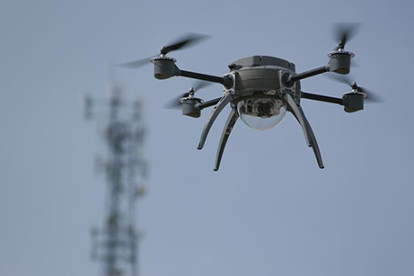
Today the Agency announced it had acquired a modern high altitude drone to use in the charting task. The drone was equipped with a high resolution camera that can capture small details from great heights.
The device was expected to enhance the Agency’s technical ability to carry out aerial photography, which is a vital part of the ongoing Maps for Sustainable Management project, a joint initiative that began in January and carried out in partnership with the Norwegian Mapping Authority.
As well as playing a vital role in the nationwide mapping project, the drone will also improve the Agency’s ability to create and provide individual maps and charts for public and private use.
The announcement noted the drone would ensure easier production of "higher quality data" and would provide more "flexible and systematic" updates.
The Public Registry said the drone was capable of capturing an area of 35-40km2per day, and contribute to improving the Agency's cartographic data compilation capacity.
As well as acquiring use of the drone, the Public Registry also upgraded its equipment used to develop special maps and photographs.
The mapping equipment was also obtained within the jointGeorgia-Norwegian project, worth €1.7 million (4.4 million GEL). The project was jointly funded by a Norwegian government grant (€1.4 million) and the Public Registry (€300,000).
Georgia's National Agency of Public Registry was the leading organisation for cartographic charting of the country's territories. The maps it produced are of high quality are frequently requested by public offices for official use, including defence, emergency, agriculture and environment sectors as well as private organisations.
The Agency also worked to create digital versions of historical and contemporary maps of Georgia, and lobbied to add cultural monuments across the country to the global Google Maps system.