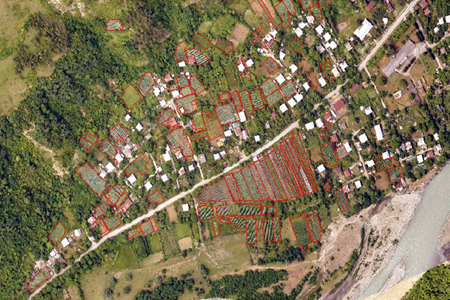
Georgia creates cadastral maps of its vineyards

Georgia has started creating cadastral maps of its vineyards, preparing alphanumeric information about viticulture and vineyards, including varieties and other characteristics.
The implementation of the vineyards cadastre program started in the Akhmeta municipality of Georgia’s wine region of Kakheti.
Contractor company of the Georgian National Wine Agency, Map Mapping, is implementing the project, taking orthophotos of vineyards by pilotless vehicles, on the bases of which cadastral maps will be prepared.
The cadastral system of vineyards represents the combination of vineyards, cultivated varieties and other data, which identify winemakers and producers employed in the wine industry.
The existence of a cadastral database is necessary to regulate the registration of vineyards, decision making in viticulture and winemaking, to properly plan the vintage process, to control wine production and its movement, to regulate viticulture and winemaking and viticulture regulation in general,” said the Wine Agency.

Company Map Mapping is taking orthophotos of vineyards by pilotless vehicles. Photo by Wines of Georgia.
The cadastral program will help wine companies to predict the raw material base and advance planning of production capabilities, which directly reflect the improvement of the financial position of the companies.
Wine producers will be able to communicate with wine companies, simultaneously, predicting the process of grape harvesting and the process of passing and accurate statistics of wine production will be developed, which will enable effective management of the field.
The National Wine Agency started implementing the vineyards cadastre program in 2014 from Racha-Lechkhumi region.
In 2015-2016 the cadastre program was implemented in Telavi and Kvareli municipalities. The program will be implemented gradually in the rest of the municipality of Kakheti, said the Wine Agency.
 Tweet
Tweet  Share
Share