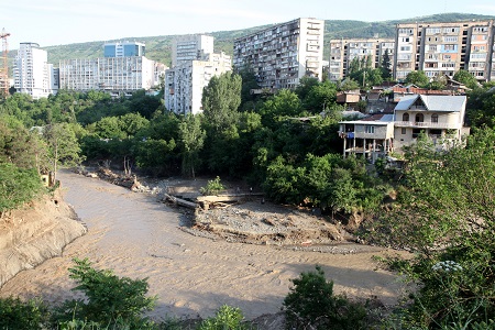
Aerial photos capture full extent of Tbilisi flood damage

The final phase of an aerial photo shoot covering 200 km2 of the Vere River basin is complete.
The series of orthophotographs capture the full extent of damage to infrastructure and the environment caused in the June 13 Tbilisi flood and will help officials rebuild the area using methods that mitigate the risks of future natural disasters.
The photos have been handed to the Ministry of Economy and Sustainable Development of Georgia to review. If any other Government agency needed the photos, the Ministry said it was willing to hand them over.
The Georgian Public Registry involved in the aerial photography project noted the images would significantly contribute to the overall understanding of the disaster, help the team better evaluate the damaged caused and implement an appropriate rehabilitation plan.
The photos would also help the team with future natural disaster planning and prevent the construction of buildings in inappropriate places.
A department within Georgia's Ministry of Justice utilised a small plane to take orthophotographs of the Vere River basin to better analyse the scale of the damage caused in the June flash flood.
The aerial photo shoot was carried out by Ukrainian company Aviation Accounting Centre along with specialists from the Georgian Public Registry, and funded by the Norwegian government.
A tender for foreign and local companies was announced earlier this year to map the entire country, which was subsequently awarded to Norwegian mapping authority Statens Kartverk. The Norwegian side selected the Ukrainian company to assist them complete the orthophotograph project, which began in January 2015.
An orthophotograph is an image that transforms a vertical aerial photograph into the equivalent of a traditional map while still retaining the advantages of a photograph, such as actual cultural and land features and the natural environment rather than representing those features using symbols and lines.
When the flood hit, Statens Kartverk decided to temporarily halt its nationwide mapping efforts and instead focus on the flood-hit areas of Tbilisi. Statens Kartverk funded this extra task and will now continue photographing the remainder of the country.
To date the total cost of the project reached €1.7 million (4.6 million GEL). Statens Kartverk are due to complete the aerial photograph project in mid-2017.
 Tweet
Tweet  Share
Share