What if your country was occupied like Georgia?

What would your country’s map look like if a fifth of it was occupied by a foreign military?
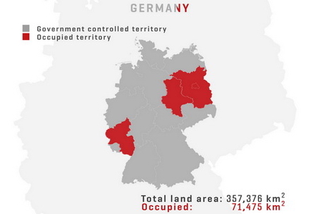
A Georgian digital designer has created an illustration of the answer to that question, replicating the reality of 20 percent of Georgia’s territory being under the control of an occupying force.
Creating for his design portfolio, Gigi Kadagishvili used minimalist digital maps of nearly 20 countries to shade a part of their total land area as if they were out of governmental control.

A UK map version of the occupation of Georgia, created by the designer. Photo: Gigi Kadagishvili Designer.
His project aims to bring closer the daily reality of Georgia’s citizens to their counterparts in foreign states.
I wished to contribute to the campaign of protesting against the Russian aggression [against Georgia]", Kadagishvili noted.

An illustration of Brazil's political map with the shading signifying hypothetial foreign de-facto control. Photo: Gigi Kadagishvili Designer.
After spending some time thinking about a relevant form for this project, I decided the best way to convey the idea would be to create a perspective for people in other countries to understand the reality our country is facing", the designer told Agenda.ge.

A fifth of the US land area shaded in red to create an impression of occupation of the territory. Photo: Gigi Kadagishvili Designer.
The produced graphics include cases for countries including the United Kingdom, Japan and Australia.
Seeking to raise awareness on the occupation of Georgia’s Abkhazia and Tskhinvali regions since the 2008 Russian-Georgian armed conflict, the visual work joins recent Georgian projects with similar goals.

A map of Turkish territory used by the artist to replicate the Georgian reality. Photo: Gigi Kadagishvili Designer.
Kadagishvili has created personal design works featuring political figures, artists and popular global brands.
Publishing his work on his social media page Gigi Kadagishvili Designer, he has also produced digital and print commissions.
 Tweet
Tweet  Share
Share